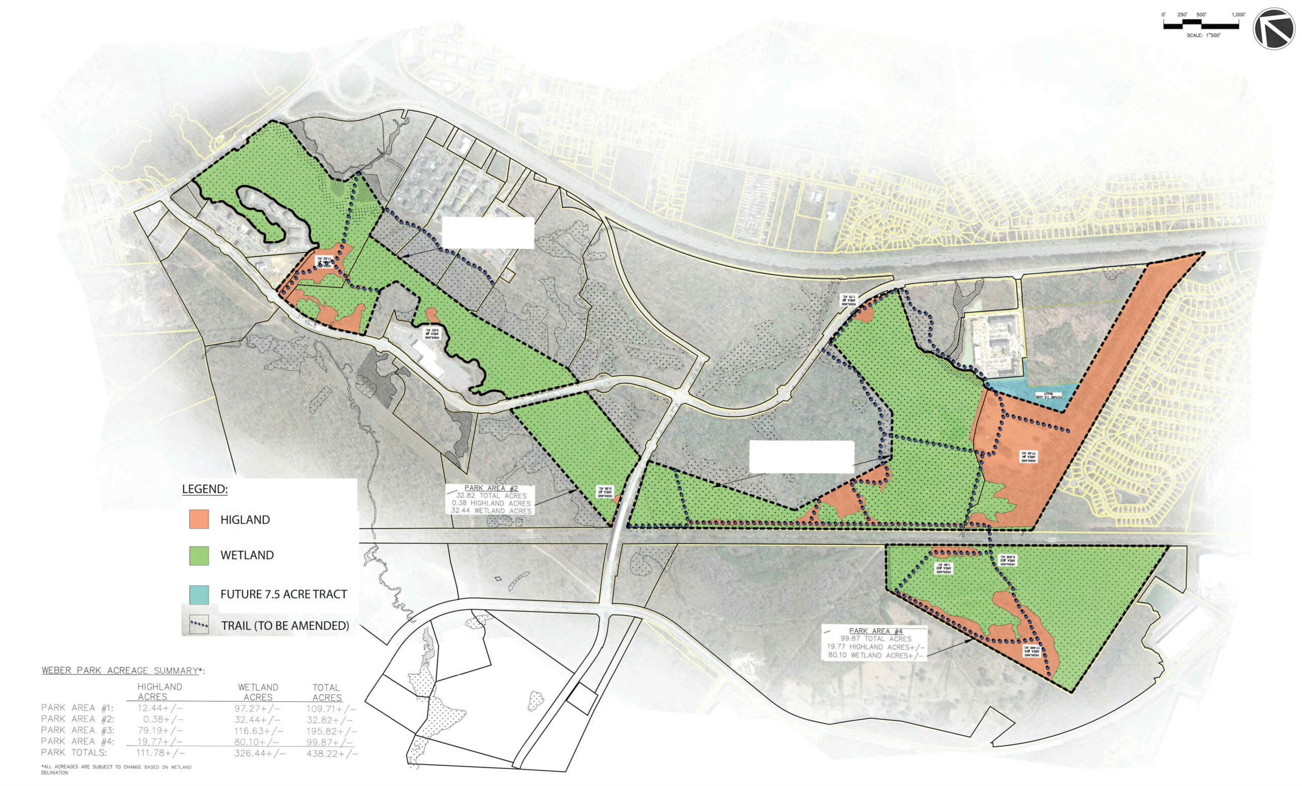
An over 400-acre park in a fast-developing section of North Charleston through the highlands and wetlands of the Blue House Swamp. The park will be accessed through a series of boardwalks and other pedestrian friendly routes.
Ingleside Park will be a central public open space covering 440 acres. The historic grounds of Ingleside Plantation have been an open area for at least 300 years and will serve as a core area of the future park. This former rice plantation has extensive trails on ancient levees through the rice fields and along the Blue House canal through the bottomland forested spine of the tract with forested upland buffers. The land is otherwise surrounded by mixed-use and industrial development, the Interstate and other public roads. The uplands extend off the Property to adjacent sidewalks, roads, and future development in the North Charleston area.
Recreational uses of the area will vary with the land’s topography and ecological features. Ingleside includes a flat, dry, upland gathering area with significant historic and scenic value. The grounds of the property encompasses over 15 acres which can accommodate small parking areas, picnic areas, and other easily-accessible uses for any visitor to the park. Readily-accessible sites like the ruins of Ingleside, the ancient Live Oaks along the row where slave homes once stood, and easy access to see wetland birds afford a unique opportunity in North Charleston to immerse one’s self in the setting of an historic Lowcountry plantation while within a walking distance of urban populations.
Passive use of the property will also include foot traffic from access points off public roads with sidewalks like Ingleside Boulevard. Multi-family housing and mixed-use developments are being built all throughout this region which will bring new residents looking for daily walking opportunities.
The tract also includes native forest habitats that provide opportunity for solitude and remoteness. Recreational opportunities extending down the 1.5 miles of forested floodplain to Blue House Canal for wildlife photography, particularly birds, plants, wildflowers, and amphibians. Existing trails on the property provide a way for communities to connect with the forest and with history. Historic rice plantations in Charleston County provide ecological and cultural opportunity for scientific study, interpretation for the public.
Ingleside Park encapsulates the Greenbelt Vision of transforming underutilized urban landscapes into greenspace for public benefit, development of on-road and off-road greenways and trails, ensuring liveability, and the hub-and-spoke model linking destinations together with greenspace corridors. (4.2) Ingleside Park is 440 undeveloped acres that is entitled as a planned development and facing significant encroaching development pressure. This property provides a linkage along the forested floodplain that extends through the development of the Weber/Ingleside in North Charleston. It uses ancient levees to become off-road greenways and trails that connect to future and existing development by adjacent landscaped roadways. The Weber/Ingleside development of residential neighborhoods, retails centers, and commercial/industrial space represent the economic growth and prosperity that the GAB intended the Greenbelt corridors to balance—an area for non-automobile transportation, outdoor recreation, protection of ecologically valuable landscapes. This landscape includes a larger corridor of protected space with Wannamaker County Park and Goose Creek Reservoir downstream.